

With all the change and uncertainty in our lives these days, sometimes it’s nice to consider a subject that is rock solid. Literally. I’m talking about the mountains, those big ol’ neighbors of ours that loom right next door. No commotion bothers them, they don’t have to check in to social media every morning to see what the latest problem is. Just like the Big Lebowski’s Dude, the mountains abide. So let’s get a little background on ‘em and when the news of the day starts to be just a little too much, we can borrow a little peace and calm from these silent giants. Photo at left: Wikimedia Commons.
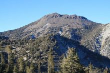
.jpg/512px-Washoe_Valley%2C_Nevada_(21154150410).jpg) I’ll start in the south end of town with my favorite mountain in the whole Carson Range. Mount Rose watches over the Galena area and makes for a postcard-perfect image in all seasons of the year. It’s the tallest of the Sierra Nevada range mountains that are in Nevada, and Mt. Rose Highway is the quickest route to Tahoe from Reno. The road zig-zags up the eastern slope and then crosses over into the Tahoe Basin by slipping in between Mount Rose to the north and Slide Mountain to the south. And if you’re trying to figure out the spatial relationship in your head, but end up confused because you’re trying to figure out how Mt. Rose Ski Area fits into the picture, don’t worry; it’s not your internal compass that is out of whack. The ski area is south of the highway, which means that it is actually physically located on the back side of Slide Mountain (which is a much more impressive mountain when viewed from the south, such as from the Washoe Valley, where you can see the sheer rock-strewn face that helps give it its name). Slide Mountain clocks in at a height of 9,698 feet, shy of Mt. Rose’s 10,778 feet. Photo at right: Wikimedia Commons, Ken Lund.
I’ll start in the south end of town with my favorite mountain in the whole Carson Range. Mount Rose watches over the Galena area and makes for a postcard-perfect image in all seasons of the year. It’s the tallest of the Sierra Nevada range mountains that are in Nevada, and Mt. Rose Highway is the quickest route to Tahoe from Reno. The road zig-zags up the eastern slope and then crosses over into the Tahoe Basin by slipping in between Mount Rose to the north and Slide Mountain to the south. And if you’re trying to figure out the spatial relationship in your head, but end up confused because you’re trying to figure out how Mt. Rose Ski Area fits into the picture, don’t worry; it’s not your internal compass that is out of whack. The ski area is south of the highway, which means that it is actually physically located on the back side of Slide Mountain (which is a much more impressive mountain when viewed from the south, such as from the Washoe Valley, where you can see the sheer rock-strewn face that helps give it its name). Slide Mountain clocks in at a height of 9,698 feet, shy of Mt. Rose’s 10,778 feet. Photo at right: Wikimedia Commons, Ken Lund.
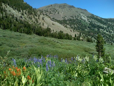 North of Mount Rose, you’ve got the Mount Rose Wilderness Area portion of the Carson Range. This terminology can sometimes confuse people who aren’t familiar with it, but in a nutshell, it’s the strictest level of protection for federal lands, and it means you can’t use any sort of machinery within its borders and you won’t find any amenities such as tables, shelters or toilets. So no chainsaws, motorcycles, cars and so on. And providing a bone of contention for some, no mountain bikes or snowmobiles. Earlier this year, someone decided to land their helicopter in Montana’s Bob Marshall Wilderness to do a bit of fishing, and they got slapped with a fine for the violation, a federal misdemeanor. But as for our own next-door Wilderness area and its mountains, we’ve got Church Peak, Mount Houghton, Relay Peak and Snowflower Mountain. None of these are quite so tall as Mount Rose, but all of them do top the 10,000-foot marker. Photo at left: flickr, Mark Taylor.
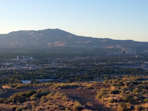 I’m going to wrap up with the big behemoth that dominates the skyline as you look northwest out of Reno. The northern border of the Carson Range is the Truckee River, so Peavine Mountain is not a part of the Carson Range, but it’s what you would hit if you crossed the river and kept trekking north. Peavine Peak tops out at 8,131 feet, but what this mountain lacks in elevation it more than makes up for in breadth and in colorful history, including lots of 1800s mining activity, namesake wild pea vines and a settlement developed by a cousin of Edgar Allan Poe (or at least that’s how the stories go). Photo at right: flickr, Mitch Barrie.
So the next time you get overwhelmed by the hustle and bustle of the world, glance up toward the west. And abide.
About the Author Keith Rugg
 R. Keith Rugg has worked on staff for a number of local publications, including Lake Tahoe Action Magazine, the Tahoe Daily Tribune and the Reno Gazette-Journal.